Geocode
Advertisement
GeodesiX v.3.0
GeodesiX is an addin for Microsoft Excel which allows you to display maps, perform forward and reverse geocoding, compute distances (Great Circle, driving, bicycling and walking) and verify your results in Google Maps, all within Excel.
Advertisement
GeoLynx CrimeAnalyst v.8.0
GeoLynx CrimeAnalyst is an extension for ESRI ArcGIS Desktop 9.3.x or 10.0 that helps you to effectively analyze, forecast, and intervene in crime series . As a crime analyst, your first task is to locate where cases are occurring.
WIA-Loader v.1.7.2.1
WIA-Loader is a feature-rich and effective freeware tool that lets you easily transfer pictures from a camera or flash card to the PC.
EZ-Locate Client v.2 47
EZ-Locate is an Internet-based geocoding service that provides real-time access to the Tele Atlas address database and geocoding technology.
IPJC v.0.5
iPJC is an easy-to-use record keeping system for the land surveying industry. It allows your staff to securely store, retrieve and cross-reference all of your company's survey database records -- of estimates, plans,

Sunrise v.1.2.0.0
Sunrise shows and optionally reminds you when sunrise, sunset, blue hour (twilight) and golden hour occurs for any location and date (on Earth that is).

GPS Calculator v.5.8.0.0
Swiss army knife for GPS. Now with Compass, Trip Computer, Track recording, GPX, KML and HTML export, SkyDrive integration and the Magnetic declination calculator! GPS Calculator allows you to get current location, accurately calculate distances

GPS Calculator PRO v.5.8.0.0
Swiss army knife for GPS. Now with Compass, Trip Computer, Track recording, GPX, KML and HTML export, SkyDrive integration and the Magnetic declination calculator! Trial is free, unlimited and fully functional! GPS Calculator allows you to get

Dashboard v.1.8.0.0
Dashboard lets you create your own collection of gauges including compass, gyroscope, speed, tilt, acceleration, heading, location, altitude, vibration, and more. Other features include brightness control, night toggle,

GPS GeoPin v.2.1.0.0
** Windows Phone 8 supported!!! GPS GeoPin provides all the location and course data calculated from your phone's global positioning satellite (GPS) receiver in conjunction with received orbiting global positioning satellite signals. ** Application
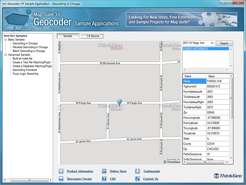
Map Suite Geocoder v.6.0.0.0
Map Suite Geocoder is a native geocoding and reverse geociding component for .